
diff options
Diffstat (limited to 'data/blogs')
| -rw-r--r-- | data/blogs/1.md | 8 | ||||
| -rw-r--r-- | data/blogs/altaf-devlog-0.md | 14 | ||||
| -rw-r--r-- | data/blogs/urban0.md | 95 |
3 files changed, 79 insertions, 38 deletions
diff --git a/data/blogs/1.md b/data/blogs/1.md index f1168ee..2a0494b 100644 --- a/data/blogs/1.md +++ b/data/blogs/1.md @@ -40,11 +40,15 @@ It was a normal day. I was thinking of backing up simpliCity using GitHub. Becau ## The Problem First, I made a new repo in GitHub, connect the git repo to the GitHub repo using **git remot**e, rename the master branch to main, and push it to GitHub using **git push**- - fatal: The push operation includes a file which exceeds GitHub's file size restriction of 100MB +```{: .txt .pre} +fatal: The push operation includes a file which exceeds GitHub's file size restriction of 100MB +``` ..Alright then. Turns out I included the temporary, automatically-generated Unity project files and folder. To fix this, I added the .gitignore template for Unity to tell Git to simply ignore the files and folder, and upload it again- - fatal: The push operation includes a file which exceeds GitHub's file size restriction of 100MB +``` {: .txt .pre} +fatal: The push operation includes a file which exceeds GitHub's file size restriction of 100MB +``` Still the same error. Turns out that I have to remove the history of the ignored file, alias I have to make git forget about all of the temp files. **And this is where I messed up.** diff --git a/data/blogs/altaf-devlog-0.md b/data/blogs/altaf-devlog-0.md index 7c7fbf0..f709c7f 100644 --- a/data/blogs/altaf-devlog-0.md +++ b/data/blogs/altaf-devlog-0.md @@ -1,12 +1,12 @@ --- title: "altaf-devlog[0]: Hello, world! And I'm sorry." -description: "No description provided." -date: "May 2026" -author: "altaf-creator" -tags: - - "simpliCity" - - "Devlog" - - "Personal" +description: No description provided. +date: Jun 2026 +author: altaf-creator +tags: + - simpliCity + - Devlog + - Personal --- +=+=+= diff --git a/data/blogs/urban0.md b/data/blogs/urban0.md index 469fb15..a55ed47 100644 --- a/data/blogs/urban0.md +++ b/data/blogs/urban0.md @@ -1,7 +1,7 @@ --- title: Reimagining Singapore's Streets with Design Thinking description: A secondary schooler's take on how we should design our streets. -date: 12 Jun 2026 +date: Tue, 16 Jun 2026 author: altaf-creator tags: - Blog @@ -21,26 +21,28 @@ The roads and streets of Singapore are widely acclaimed to be world-class. This The traffic engineering in Singapore is definitely world-class. However, I feel like Singapore has been building its streets too much in an engineering lens. -To be clear, the issue is not that traffic engineering is unimportant. Efficient traffic acts as the veins that keep Singapore alive. Without it, economic productivity and people's daily commute will be severely crippled. However, roads and streets are not only built to accommodate efficient traffic flow. +To be clear, the issue is not that traffic engineering is unimportant. Efficient traffic acts as the veins that keep Singapore alive. Without it, economic productivity and people's daily commute will be severely crippled. However, roads and streets are not built only to accommodate efficient traffic flow. Streets inherently are spaces for humans. A street's function is more than connecting places to places. A street can be a place where people connect with each other. It can be a place where people discover new things around their neighbourhood. There is an inextricable social part in streets. When we ignore it, that is, when we design our streets purely in an engineering perspective (despite the name "traffic engineering"), we are reducing a street's functionality from a place for the community to merely a traffic conduit. <div class="shadow-filter" markdown="1"> 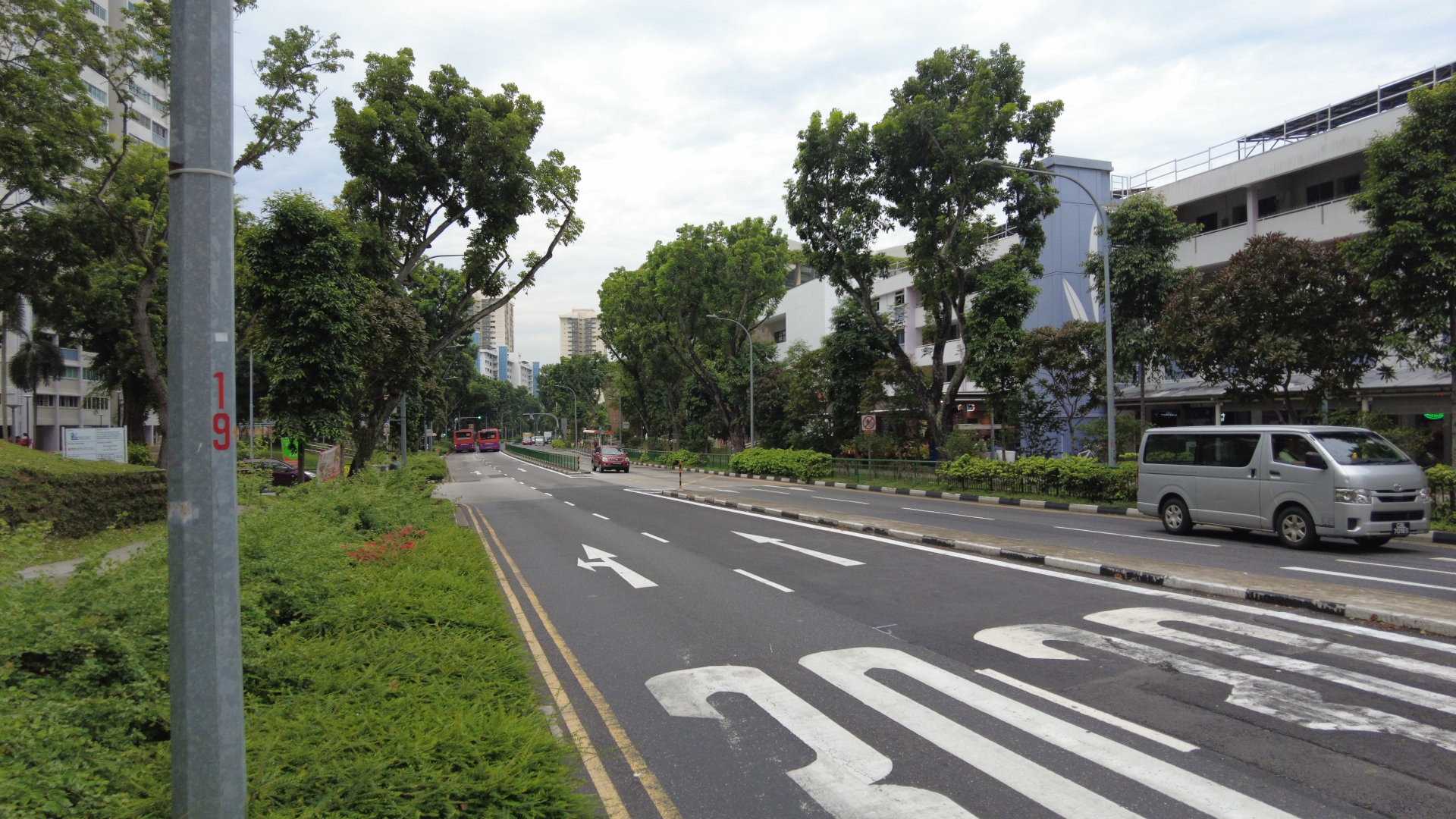 </div> -View of Bedok North St 1, a street near Bedok Town Centre and Heartbeat@Bedok. Despite being a silver zone, the carriageway is still fairly wide with 4 lanes of vehicular traffic. Photograph taken by me. <i class="fa-brands fa-creative-commons"></i><i class="fa-brands fa-creative-commons-by"></i><i class="fa-brands fa-creative-commons-sa"></i> CC-BY-SA 4.0 +View of Bedok North St 1, a street near Bedok Town Centre and Heartbeat@Bedok. Despite being a Silver Zone, the carriageway is still fairly wide with 4 lanes of vehicular traffic. Photograph taken by me. <i class="fa-brands fa-creative-commons"></i><i class="fa-brands fa-creative-commons-by"></i><i class="fa-brands fa-creative-commons-sa"></i> CC-BY-SA 4.0 {: .img-caption } -This is what I feel like I'm seeing in Singapore. There are many instances where wide 4-lane roads are cutting through town centres of heartlands, despite being categorised as a local access road. Town centres are vibrant places bustling of activities and businesses. Regardless of people's background and age, these are places where people want to spend their time in. Having wide roads cutting through it will make it harder for people to explore and find out about new businesses near that place. It may also be harder for residents living across the road to walk there, despite their close proximity, as wide roads for vehicles can act as a physical barrier that reduces permeability. Not only that, vehicles are polluting, and wide roads that facilitate vehicular movement will make the environment around it more uncomfortable to spend time in, which is contradictory of the characteristics of a town centre. +This is what I feel like I'm seeing in Singapore. There are many instances where wide 4-lane roads are cutting through town centres of heartlands, despite being categorised as a local access road. Town centres are vibrant places bustling with activities and businesses. Regardless of people's background and age, these are places where people want to spend their time. Having wide roads cutting through it will make it harder for people to explore and find out about new businesses near that place. It may also be harder for residents living across the road to walk there, despite their close proximity, as wide roads for vehicles can act as a physical barrier that reduces permeability. Not only that, vehicles are polluting, and wide roads that facilitate vehicular movement will make the environment around it more uncomfortable to spend time in, which is contradictory to the characteristics of a town centre. -There is also the impacts on road safety. Conventional road design in Singapore often features wide and straight lanes in arterial roads and local streets. Drivers subconsciously associate these characteristics with faster driving, just like how they would drive in expressways, disregarding the speed limit of that street. In an unfortunate circumstance of a traffic accident, higher speeds will result in more fatal consequences. In fact, the risk of a pedestrian fatality increases exponentially with the collision speed[^1]. Places such as town centres should be a place where people can navigate freely with peace of mind, rather than a high-speed thoroughfare that compromises safety. +There are also the impacts on road safety. Conventional road design in Singapore often features wide and straight lanes in arterial roads and local streets. Drivers subconsciously associate these characteristics with faster driving, just like how they would drive in expressways, disregarding the speed limit of that street. In an unfortunate circumstance of a traffic accident, higher speeds will result in more fatal consequences. In fact, the risk of a pedestrian fatality increases exponentially with the collision speed[^1]. Places such as town centres should be a place where people can navigate freely with peace of mind, rather than a high-speed thoroughfare that compromises safety. -As of 2024, the road network in Singapore occupies 12% of Singapore's total land area[^2]. This is a significant portion of land-scarce Singapore, even comparable to the total land area allocated for housing (14%)[^3]. Since road infrastructure in Singapore covers such a large area, making sure that we design our roads and streets correctly, that is designing roads that accommodates the needs of everyone, not just the flow of vehicles, is very important. Therefore, designing our roads and streets with empathy is crucial. +As of 2024, the road network in Singapore occupies 12% of Singapore's total land area[^2][^3]. This is a significant portion of land-scarce Singapore, even comparable to the total land area allocated for housing (14%)[^3]. Since road infrastructure in Singapore covers such a large area, making sure that we design our roads and streets correctly, that is designing roads that accommodates the needs of everyone, not just the flow of vehicles, is very important. Therefore, designing our roads and streets with empathy is crucial. -+-+-+ +=+=+= +# Design Thinking + This is where **design thinking** can come in. Design thinking generally refers to a human-centered methodology that designers can use to ensure that they solve problems by prioritising the needs of the users[^4]. There are numerous frameworks of design thinking out there, but they all generally have a common theme of listening and **empathising** to problems that a target audience faces, and focusing on solving them. For this post, I'll use a very common 5-staged design thinking framework. The stages include: empathise, define, ideate, prototype, and test. @@ -53,8 +55,10 @@ The 5 iterative stages of Design Thinking: empathise, define, ideate, and protot Let's go through a brief explanation of each of these five stages[^9]. +==shorten this section?== + 1. **Empathise.** This is a stage where we understand the problems and needs of the people within the context of a problem. Empathy is the main feature of a human centric design process like design thinking. We can do this by listening and engaging with people directly and/or observing people's behaviour. -2. **Define.** The data we gathered from people may be messy and can be quite overwhelming. This is the stage where we bring clarity to the problem we are tackling. We can do this by crafting a problem statement, kind of like a point-of-view. This way, it will be clearer of what problem we are actually solving for everyone. +2. **Define.** The data we gathered from people may be messy and can be quite overwhelming. This is the stage where we bring clarity to the problem we are tackling. We can do this by crafting a problem statement, kind of like a point-of-view. This way, it brings clarity to everyone of what problem we are actually solving. 3. **Ideate.** This is the stage where we think of solutions and generate... well... ideas! In this stage, we are focusing on generating as broad of a range of solutions as possible. We won't truly know whether any idea is good or not, but that is where the next stage comes in. 4. **Prototype.** This is where we try out different ideas and create quick and cheap prototypes that can still bring in useful feedback from your team and users. This stage serves many purposes, from being another way to ideate, communicate your idea to users via an example, and to test out different ideas to see whether they work or not. 5. **Test.** This stage is very related to the previous stage. This is the stage where we can see whether our prototypes work well, by giving users the chance to use the prototypes. This is also the stage where we can listen to further feedback and adjust accordingly. In fact, this stage can also be used to refine our problem statement/point-of-view. @@ -63,16 +67,16 @@ Design thinking can be effective since it eliminates biases of the problem solve The reason why I am bringing up design thinking is because it is often taught in Singapore schools. - +In the Ministry of Education's national curriculum, Design & Technology (D&T) is currently a compulsory subject for lower secondary students. One of the core concepts taught in the D&T syllabus is Design Thinking, where pupils will learn along the way the thought processes of design thinking itself, seeking solutions by considering the needs of users, functionality, and environment[^5]. Academic competitions that encourage students to learn and apply design thinking principles also exist, such as SUTD's STEAMunity, a STEM problem solving competition[^6]. These sort of activities teaches pupils that in the process of creating and designing something, empathy is essential to create solutions that actually help people. -In the Ministry of Education's national curriculum, Design & Technology (D&T) is currently a compulsory subject for lower secondary students. One of the core concepts taught in the D&T syllabus is Design Thinking, where pupils will learn along the way the thought processes of design thinking itself, seeking solutions by considering the needs of users, functionality, and environment[^5]. Academic competitions that encourage students to learn and apply design thinking principles also exist, such as SUTD's STEAMunity, a STEM problem solving competition[^6]. These sort of activities teaches pupils that in the process of creating and designing something, empathy is essential to ensure (problem is solved) - -This shows Singapore already considers empathy as an important aspect in engineering. Having already embraced human-centric design process in education, the same principles can also be applied to how we design our streets. +This shows Singapore already considers empathy as an important aspect in engineering. Having already embraced the human-centric design process in education, the same principles can also be applied to how we design our streets. -+-+-+ +=+=+= +# Let's apply it! + Let's see how design thinking can be applied in road design to make it more human-centric. ## Stage 1: Empathise @@ -80,7 +84,11 @@ Let's see how design thinking can be applied in road design to make it more huma <div class="shadow-filter" markdown="1"> 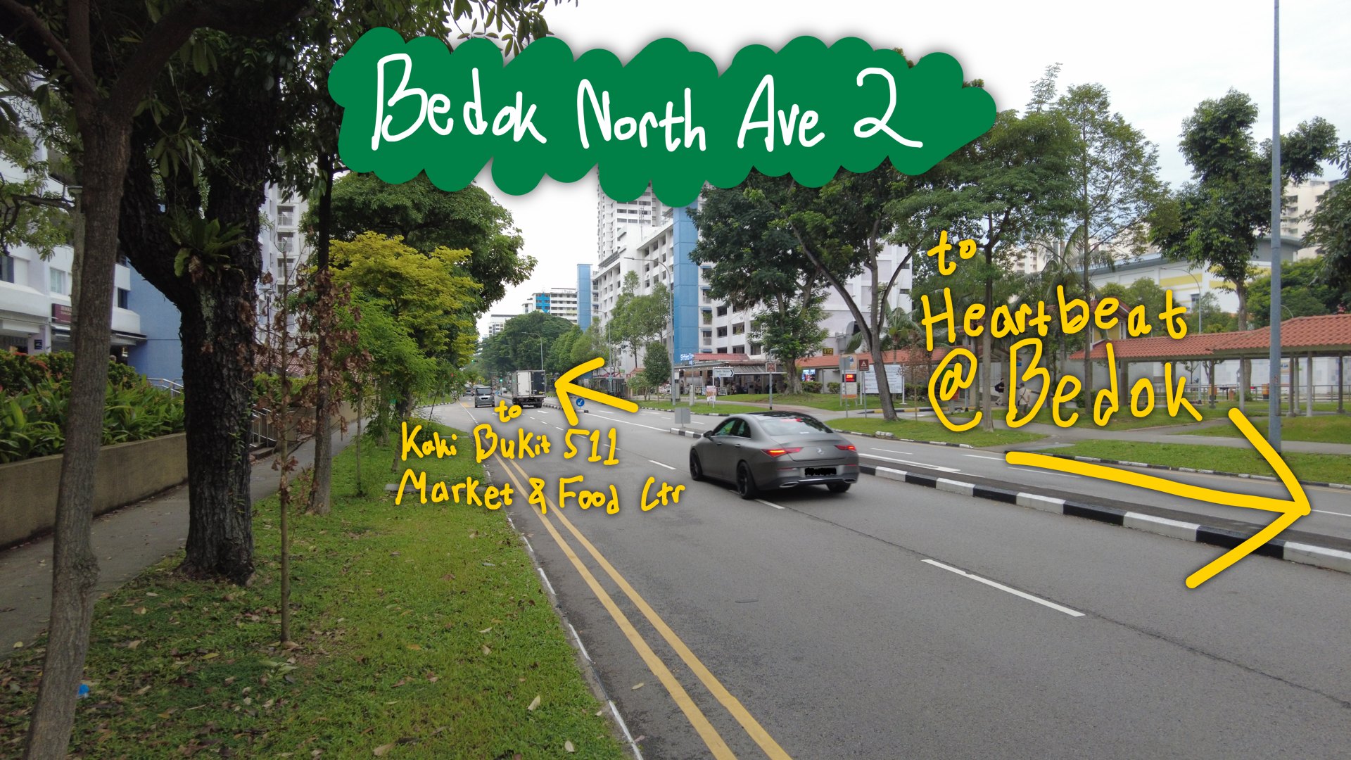 </div> -Side view of Bedok North Ave 2. Photograph taken by me. <i class="fa-brands fa-creative-commons"></i><i class="fa-brands fa-creative-commons-by"></i><i class="fa-brands fa-creative-commons-sa"></i> CC-BY-SA 4.0 +<div class="shadow-filter" markdown="1"> +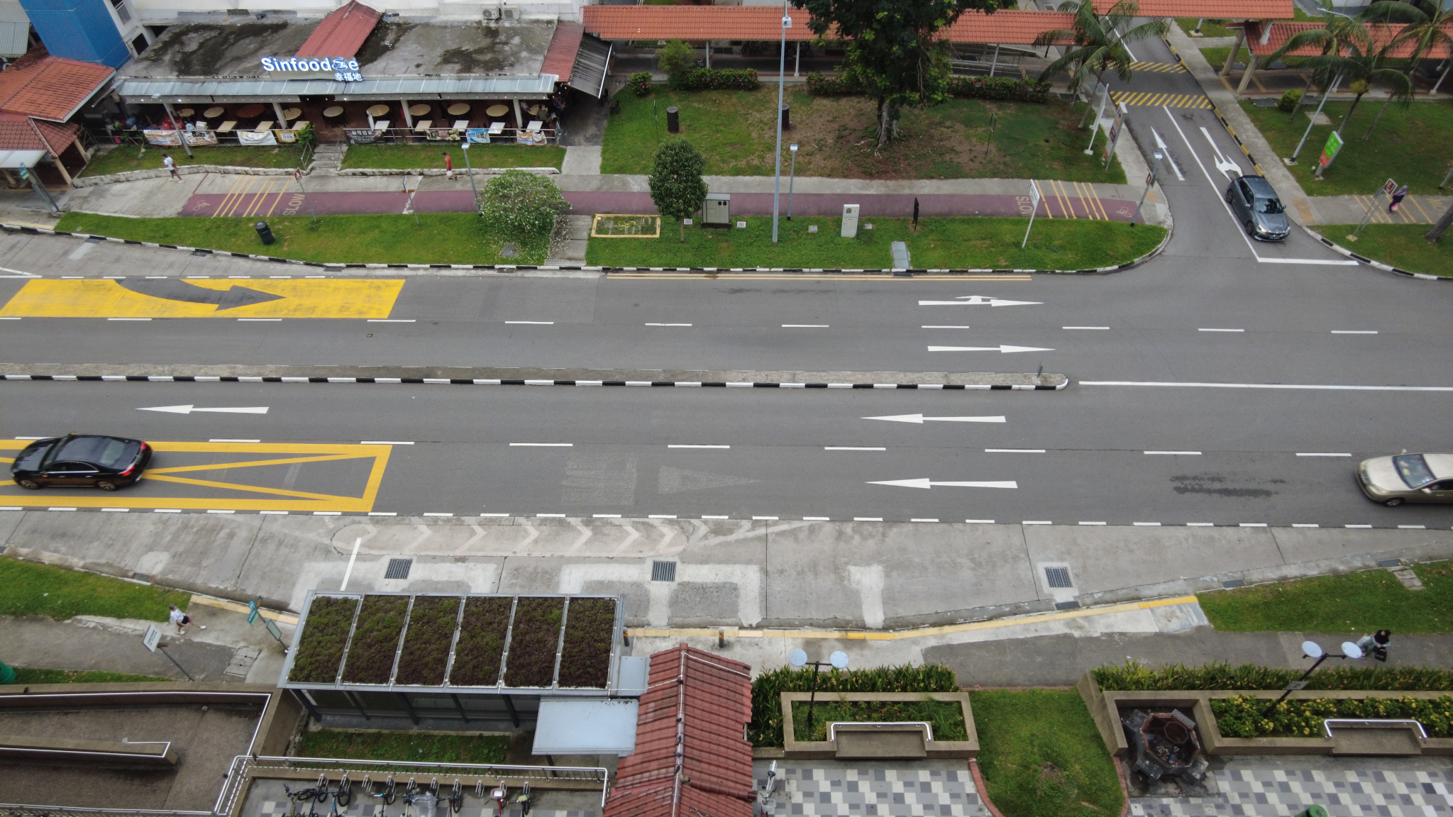 +</div> + +Side and top view of Bedok North Ave 2. Photographs taken by me. <i class="fa-brands fa-creative-commons"></i><i class="fa-brands fa-creative-commons-by"></i><i class="fa-brands fa-creative-commons-sa"></i> CC-BY-SA 4.0 {: .img-caption } This is Bedok North Ave 2, a street that serves Kaki Bukit neighbourhood centre at its northern end, numerous HDB precincts, and Heartbeat@Bedok at its southern end. Despite having "Avenue" in its name (which is usually reserved for Major Arterial/Category 2 roads), it is officially classified as a Category 4 road[^7], which means that it is a primary access road/street that provides access to developments[^8]. Despite being a local street though, it has a pretty wide and straight 4-lane carriageway (the portion of road for vehicular traffic), no bus lanes, footpaths on both sides, and a cycling path on only one side. @@ -88,6 +96,9 @@ This is Bedok North Ave 2, a street that serves Kaki Bukit neighbourhood centre Being one of the first HDB towns built, Bedok is a mature estate, and in this particular neighbourhood, there is a higher number of elderly living here. I also often see high amounts of foot traffic along the footpaths since I cycle there often. Additionally, this route is a popular route for cyclists and PMD/PMA users to go to Bedok Town Centre, so there are also a lot of cyclists on this street. Furthermore, from my personal observations, there is often little traffic going through this street. This makes the 4-lane carriageway built here feel overkill, as they take up a vast amount of space on this street. This makes crossing the street inherently more dangerous, which is amplified by the high footfall on this street. For drivers, this street serves as a primary access street, and there are quite a number of HDB car park driveways connected. Due to its 4-lane configuration, some manoeuvres will require drivers to cross 2 lanes of opposing traffic which increases the number of conflict points that makes it more dangerous for them too. + +Lastly, this section of Bedok North Ave 2 between Bedok North Rd and its southern end only has one mid-block **signalised** pedestrian crossing. For people living near this ~330 m stretch of this street, they only have three options to cross, the signalised intersection of Bedok North Ave 2 and Bedok North Rd, the mid-block signalised pedestrian crossing I mentioned, and the signalised intersection at the end of Bedok North Ave 2, near Heartbeat@Bedok. Each of these crossings are around 140-190 metres apart. For pedestrians, these distances may be too far which may make walking feel inconvenient, and for the elderly, these distances may make walking physically more demanding. This is especially important to consider for this street due to the high number of elderly residents living nearby. If crossings are perceived as too far, pedestrians may instead "jaywalk" and cross the 4-lane carriageway, which presents significant safety risks, especially given the observed demographics. + ## Stage 2: Define Considering these circumstances, carriageway being too wide, high number of cyclists and foot traffic, and high number of elderly residents living nearby, the current design of Bedok North Ave 2 may not be optimal for what it serves. Instead, Bedok North Ave 2 should prioritise safety for everyone, pedestrians, cyclists, and drivers included, and convenience of walking and cycling. @@ -106,39 +117,64 @@ Let's take some very rough measurements. I'll take my own quick measurements of * Total carriageway width (median absent): ~14.0 m * Therefore, ~3.5 m lane width * East side roadside elements - * Green verge: 3.60 m + * Green verge: 3.5 m * Cycling path: 2.00 m * Footpath: 1.56 m * West side roadside element - * Green verge: 3.54 m + * Green verge: 3.5 m * Footpath: 1.86 m -Firstly, let's remove two of the lanes from the carriageway to turn this street into a simpler 2-lane bi-directional street. We can also make the lanes a bit narrower from 3.5 m to 3.2 m. There are two bus services plying this street, 137 and 225W/225G. We can retain the presence of bus bays on this street if we are really so concerned about traffic flow, or even make the bus stop into an in-lane bus stop. That way, while busses stopping will halt the entire traffic flow in that direction, we will have more space for sidewalks, cycling paths, and green verges, and it eliminates delays from buses merging back into traffic. But for now, let's just retain the bus bays. +**Total width:** 26 m, rounded to the nearest whole number. + +Firstly, let's remove two of the lanes from the carriageway to turn this street into a simpler 2-lane bi-directional street. We can also make the lanes a bit narrower from 3.5 m to 3.2 m. There are two bus services plying this street, 137 and 225W/225G. We can retain the presence of bus bays on this street if we are really so concerned about traffic flow, or even make the bus stop into an in-lane bus stop. That way, while busses stopping will halt the entire traffic flow in that direction, we will have more space for sidewalks, cycling paths, and green verges, and it eliminates delays from buses merging back into traffic. + +This narrower road also allows us to add more crossings that are safer for pedestrians and cyclists. This also makes a raised zebra crossing pretty safe to use on this street, meaning that we can remove the traffic signals that the existing crossings have. This way, pedestrians and cyclists do not need to wait unnecessarily to cross this street, while still having the traffic calming effect that also forces vehicles to yield to pedestrians, making a raised zebra crossing safe. We can also add another raised zebra crossing on this stretch of this street to further reduce crossing distances of pedestrians and cyclists, and I think we can do so while still having enough distance between them for vehicles to safely drive through. So, let's switch up the existing signalised pedestrian crossing with a raised zebra crossing, and add an additional raised zebra crossing too. From that alone, we've freed up 7.6 m worth of street space! Currently, the footpaths and cycling path here do meet LTA's minimum standards according to their Walking and Cycling Design Guide[^11]. However, LTA's minimum standards are still quite narrow compared to international standards, especially for a bi-directional cycling path. For instance, the United Kingdom's Cycle Infrastructure Design (LTN 1/20) guide sets out a desirable minimum width of 3.0 m to 4.0 m for a 2 way cycling path depending on bicycle traffic[^13]. So, let's take this opportunity to finally add another cycling path on the west side of the street, and widen these paths. We will also widen the footpaths on both sides of the street to improve walking comfort for everyone. The widened footpaths also ensure that groups of people that want to walk side-by-side have sufficient space and don't need to overflow to the cycling path. -Last year, LTA started enforcement that prohibits bicycles to use pedestrian-only paths and encourages pedestrians to use their own paths[^14]. Despite that, I still frequently observe cyclists using pedestrian-only paths and pedestrians walking on cycling paths. One of the causes of this may be due to the nature of most cycling paths in Singapore, where they are placed adjacent to pedestrian-only paths without clear physical separation. As a result, cyclists may need to veer onto pedestrian-only paths to avoid people walking on cycling paths, and pedestrians are not guaranteed a peace of mind since they may think that they need to watch out for cyclists using their paths. Therefore, we can try putting a buffer between the footpaths and cycling paths using either a kerb or a green verge. Not only does this increase comfort for cyclists and pedestrians, this also increases safety as the design minimises possible conflicts. If we want to upgrade the physical separation further, we can implement level differences between the cycling path and footpaths, or even use the existing 3.56 m-wide green verge as the buffer between the footpaths and cycling paths. +Last year, LTA started enforcement that prohibits bicycles to use pedestrian-only paths and encourages pedestrians to use their own paths[^14]. Despite that, I still frequently observe cyclists using pedestrian-only paths and pedestrians walking on cycling paths. One of the causes of this may be due to the nature of most cycling paths in Singapore, where they are placed adjacent to pedestrian-only paths without clear physical separation. As a result, cyclists may need to veer onto pedestrian-only paths to avoid people walking on cycling paths, and pedestrians are not guaranteed a peace of mind since they feel the need to watch out for cyclists using their paths. A possible solution is by putting a physical buffer between the footpaths and cycling paths, like a kerb or a green verge. Not only does this increase comfort for cyclists and pedestrians, this also increases safety as the design minimises possible conflicts. If we want to upgrade the physical separation even further, we can implement level differences between the cycling path and footpaths, or even use the existing 3.56 m-wide green verge as the buffer between the footpaths and cycling paths. But for this concept, let's just use a simple 0.5 m green buffer between the footpath and cycling path. + +After reallocating the road space, our concept for our redesigned street would have the following approximate cross-section: + +* Carriageway: 2 × 3.2 m lanes +* Roadside elements, for both sides + * Green verge: 3.5 m + * Cycling path: 3.5 m + * Green buffer: 0.5 m + * Footpath: 2.5 m + +**Total width**: 26 m, rounded to the nearest whole number. + +Also, our concept only redistributes street space, without needing to acquire additional land at all! <div class="shadow-filter" markdown="1"> - +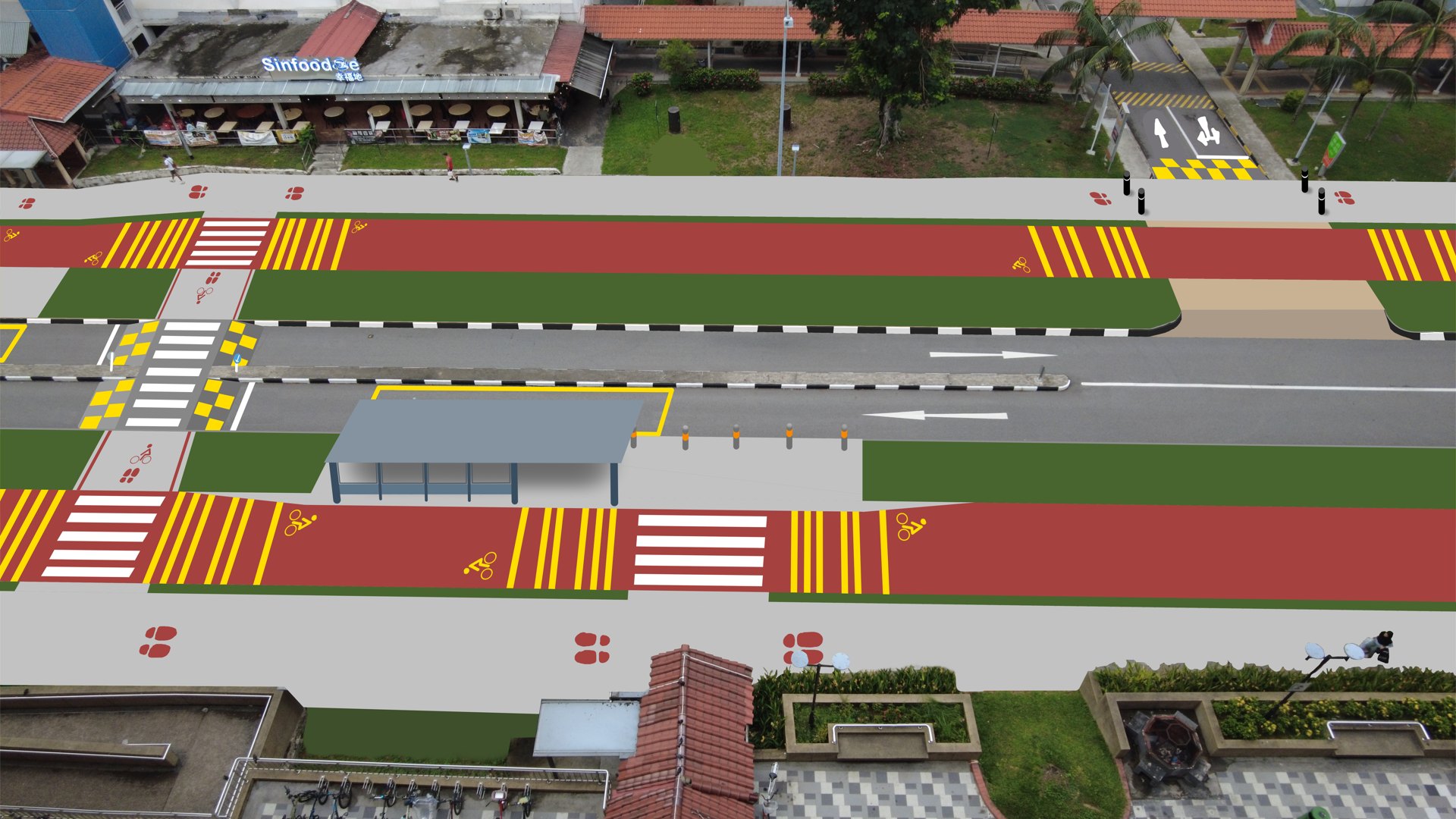 </div> + +Tada! A sketch of our Bedok North Ave 2 redesign concept. Illustration by me.<i class="fa-brands fa-creative-commons"></i><i class="fa-brands fa-creative-commons-by"></i><i class="fa-brands fa-creative-commons-sa"></i> CC-BY-SA 4.0 +{: .img-caption } + +And again, it is important to note that this redesign is intended just as a concept rather than a formal proposal. As a secondary school student, I do not have access to real-world data such as traffic volumes, bus service operations, emergency vehicle requirements, and other important data that should be put into consideration. As such, as you might have already noticed, this redesign idea has been developed primarily from existing road conditions and personal observations that may not fully reflect the whole picture. Nevertheless, I still hope that this idea serves as an example of how we can apply design thinking principles to design streets that are safer, more inclusive, and better suited to everyone's needs. ## Stage 4 & 5: Prototyping and Testing -Of course, we don't have the authority and resources to make real physical changes to the street. For these two stages, +Of course, we don't have the authority and resources to make real physical changes to the street. In the context of design thinking, our quick illustration above can actually serve as a low-fidelity digital prototype or a proof of concept. + +In the professional world, traffic engineers may come up with different ideas for a road/street redesign. Sometimes, they may want to see more concrete and functional prototypes to really evaluate each idea. A mere drawing that acts more like proof of concept is most likely not enough. Instead of spending huge amounts of money for a full construction of an idea that may very well change, many traffic engineers utilise plastic panels and temporary road barriers to redefine road space. Pop-up planters can also be used to create temporary pedestrians' and cyclists' space as it offers a physical barrier from road traffic and has a nice visual appearance. These methods are great to test and observe how traffic would flow and function, and also allow them to evaluate the efficacy of an idea. -+-+-+ +=+=+= -Fortunately, things are already getting better, albeit incrementally. The Land Transport Authority (LTA) has pushed numerous initiatives that shift the focus away from cars to people in designing the streets of Singapore. +# The Road Ahead +Fortunately, things are already getting better, albeit incrementally. As you might have known, Singapore has been pushing the car-lite vision quite a lot as of lately. The Land Transport Authority (LTA) has pushed numerous initiatives that shift the focus away from cars to people in designing the streets of Singapore, in alignment with this vision. Here are some of them. ## LTA Road Repurposing <div class="iframe-manual-container flex-container gap" id="iframe-googlemaps"> <iframe src="about:blank" data-src="https://www.google.com/maps/embed?pb=!4v1781248770546!6m8!1m7!1shv0RJ7fduSSV4znKDkQOvA!2m2!1d1.439052279883805!2d103.8006751428792!3f24.573714104988387!4f-3.9544474037450215!5f0.7820865974627469" height="240" style="border:0;" allowfullscreen="" loading="lazy" referrerpolicy="no-referrer-when-downgrade" data-iframe-manual id="iframe-google-0" class="flex"></iframe> <iframe src="about:blank" data-src="https://www.google.com/maps/embed?pb=!4v1781248791238!6m8!1m7!1s1iGF1oI4_Zl6-t5FC9i6SQ!2m2!1d1.439064512003263!2d103.8006792107188!3f24.573714104988387!4f-3.9544474037450215!5f0.7820865974627469" height="240" style="border:0;" allowfullscreen="" loading="lazy" referrerpolicy="no-referrer-when-downgrade" data-iframe-manual id="iframe-google-1" class="flex"></iframe> <div class="iframe-manual-warning shadow-filter"> -<div> +<div class="iframe-manual-notice"> <span>The following contains 3rd party content from Google. Google may be able to track you and use 3rd party cookies.</span> <button class="button button-inline" onclick="iframeLoad('iframe-googlemaps')">Load External Embed</button> </div> @@ -148,16 +184,16 @@ Fortunately, things are already getting better, albeit incrementally. The Land T Woodlands Ring Rd in 2019 (left/top) vs 2020 (right/bottom), before and after road repurposing works were done. External embed of Google Maps Street View. {: .img-caption .img-caption-margin } -For instance, LTA has completed several [road repurposing](https://www.lta.gov.sg/content/ltagov/en/upcoming_projects/road_commuter_facilities/road_repurposing.html) projects. These are projects where LTA is experimenting and reworking several roads and/or streets to better support active mobility and to make the environment more liveable and inclusive.[^12] LTA often does this by either reclaiming vehicle lanes from the carriageway for wider footpaths, cycling paths, and other commuter facilities, like Woodlands Ring Rd as seen above, or even pedestrianising whole stretches of a street, like Eng Hoon St[^12]. This is great, and I'm really looking forward to future road repurposing projects. - +For instance, LTA has completed several [road repurposing](https://www.lta.gov.sg/content/ltagov/en/upcoming_projects/road_commuter_facilities/road_repurposing.html) projects. These are projects where LTA is experimenting and reworking several roads and/or streets to better support active mobility and to make the environment more liveable and inclusive.[^12] LTA often does this by either reclaiming vehicle lanes from the carriageway for wider footpaths, cycling paths, and other commuter facilities, like Woodlands Ring Rd as seen above, or even pedestrianising whole stretches of a street, like Eng Hoon St[^12]. This is great, it really shows the paradigm shift within LTA on how Singapore's streets should be designed, and I'm really looking forward to future road repurposing projects. These projects still feel like exceptions that should have been the normal way of building our streets, though. But, things may change significantly in the future. ## LTA Land Transport Masterplan Refresh -* LTA Road repurposing projects - * Although feels like exceptions that should have been the norm. - * But... things may significantly change in the future. OR This may not be the case anymore itf! -* LTA LTMP 2026 Refresh +Land Transport Masterplan, or LTMP for short, are long-term plans by LTA that includes the vision, policies, and targets of Singapore's land transport. Very recently, LTA underwent a nation-wide public consultation for the [Land Transport Master Plan Refresh](https://www.lta.gov.sg/content/ltagov/en/who_we_are/our_work/land_transport_master_plan_refresh.html) in late 2025 and early 2026. Those recent consultations were organised for the next edition of LTA's LTMP, the [Land Transport Master Plan 2040](https://www.lta.gov.sg/content/ltagov/en/who_we_are/our_work/land_transport_master_plan_2040.html), or LTMP 2040 for short. For the upcoming masterplan, LTA is "envisioning a more inclusive and gracious" land transport for Singapore, which is quite promising. + +LTA has recently published the compiled insights from numerous focus group discussions they held during the recent public consultation phase, in which you can view it for yourselves [here](https://www.lta.gov.sg/content/dam/ltagov/who_we_are/our_work/LTMP/Image/Compiled%20Focus%20Group%20Insight.pdf)! Some of the main talking points from these focus group discussions, as reported by LTA were strong support for people-centric transport infrastructure. This includes better public transport connectivity, reliability, speed, and comfort, more mobility options such as walking and cycling, slowing down vehicle speeds in neighbourhoods, increased safety, and a lot more[^15]. + +This form of public engagement is also a form of application of design thinking! -As of recently, LTA is actively undergoing a nation-wide public consultation for the [Land Transport Master Plan Refresh](https://www.lta.gov.sg/content/ltagov/en/who_we_are/our_work/land_transport_master_plan_refresh.html). +Oh shit I need to end this too. -+-+-+ @@ -173,6 +209,8 @@ Hello there! Introduce yourself. ///Footnotes Go Here/// +-+-+-+ + [^1]: [https://road-safety.transport.ec.europa.eu/eu-road-safety-policy/priorities/safe-road-use/safe-speed/archive/speeding/speed-central-issue-road-safety/speed-and-injury-risk-different-speed-levels_en](https://road-safety.transport.ec.europa.eu/eu-road-safety-policy/priorities/safe-road-use/safe-speed/archive/speeding/speed-central-issue-road-safety/speed-and-injury-risk-different-speed-levels_en), accessed 9 Jun 2026 [^2]: [https://www.mot.gov.sg/news-resources/newsroom/written-reply-to-parliamentary-question-on-land-allocation-for-roads-and-car-parks-since-2010-and-future-policy-considerations/](https://www.mot.gov.sg/news-resources/newsroom/written-reply-to-parliamentary-question-on-land-allocation-for-roads-and-car-parks-since-2010-and-future-policy-considerations/#:~:text=Singapore%E2%80%99s%20road%20network%20occupies%20around%2012%25%20of%20our%20total%20land%20area%20today), accessed 9 Jun 2026 [^3]: [https://data.gov.sg/datasets/d_0ad604387b5b2dd99fbf48d89cb4f416/view](https://data.gov.sg/datasets/d_0ad604387b5b2dd99fbf48d89cb4f416/view), accessed 9 Jun 2026 @@ -187,5 +225,4 @@ Hello there! Introduce yourself. [^12]: [https://www.lta.gov.sg/content/ltagov/en/upcoming_projects/road_commuter_facilities/road_repurposing.html](https://www.lta.gov.sg/content/ltagov/en/upcoming_projects/road_commuter_facilities/road_repurposing.html), accessed 12 Jun 2026. [Archived](https://web.archive.org/web/20260612070039/https://www.lta.gov.sg/content/ltagov/en/upcoming_projects/road_commuter_facilities/road_repurposing.html) [^13]: [https://assets.publishing.service.gov.uk/media/5ffa1f96d3bf7f65d9e35825/cycle-infrastructure-design-ltn-1-20.pdf](https://assets.publishing.service.gov.uk/media/5ffa1f96d3bf7f65d9e35825/cycle-infrastructure-design-ltn-1-20.pdf), accessed 13 Jun 2026. [Archived](https://web.archive.org/web/20260613021824/https://assets.publishing.service.gov.uk/media/5ffa1f96d3bf7f65d9e35825/cycle-infrastructure-design-ltn-1-20.pdf). [^14]: [https://www.lta.gov.sg/content/ltagov/en/newsroom/2025/7/news-releases/pedestrian-only_paths_enforcement_starts_1Jul25.html](https://www.lta.gov.sg/content/ltagov/en/newsroom/2025/7/news-releases/pedestrian-only_paths_enforcement_starts_1Jul25.html), accessed 13 Jun 2026. [Archived](https://web.archive.org/web/20260613033237/https://www.lta.gov.sg/content/ltagov/en/newsroom/2025/7/news-releases/pedestrian-only_paths_enforcement_starts_1Jul25.html) - --+-+-+
\ No newline at end of file +[^15]: [https://www.lta.gov.sg/content/ltagov/en/who_we_are/our_work/land_transport_master_plan_refresh.html](https://www.lta.gov.sg/content/ltagov/en/who_we_are/our_work/land_transport_master_plan_refresh.html), accessed 17 Jun 2026. [Archived](https://web.archive.org/web/20260617024642/https://www.lta.gov.sg/content/ltagov/en/who_we_are/our_work/land_transport_master_plan_refresh.html). |